.png?w=auto&h=400)
.jpg?w=1080&dpr=2)
.jpg)
About the Gallery of Maps in Vatican Museums
Explore the Gallery of Maps in Vatican Museums

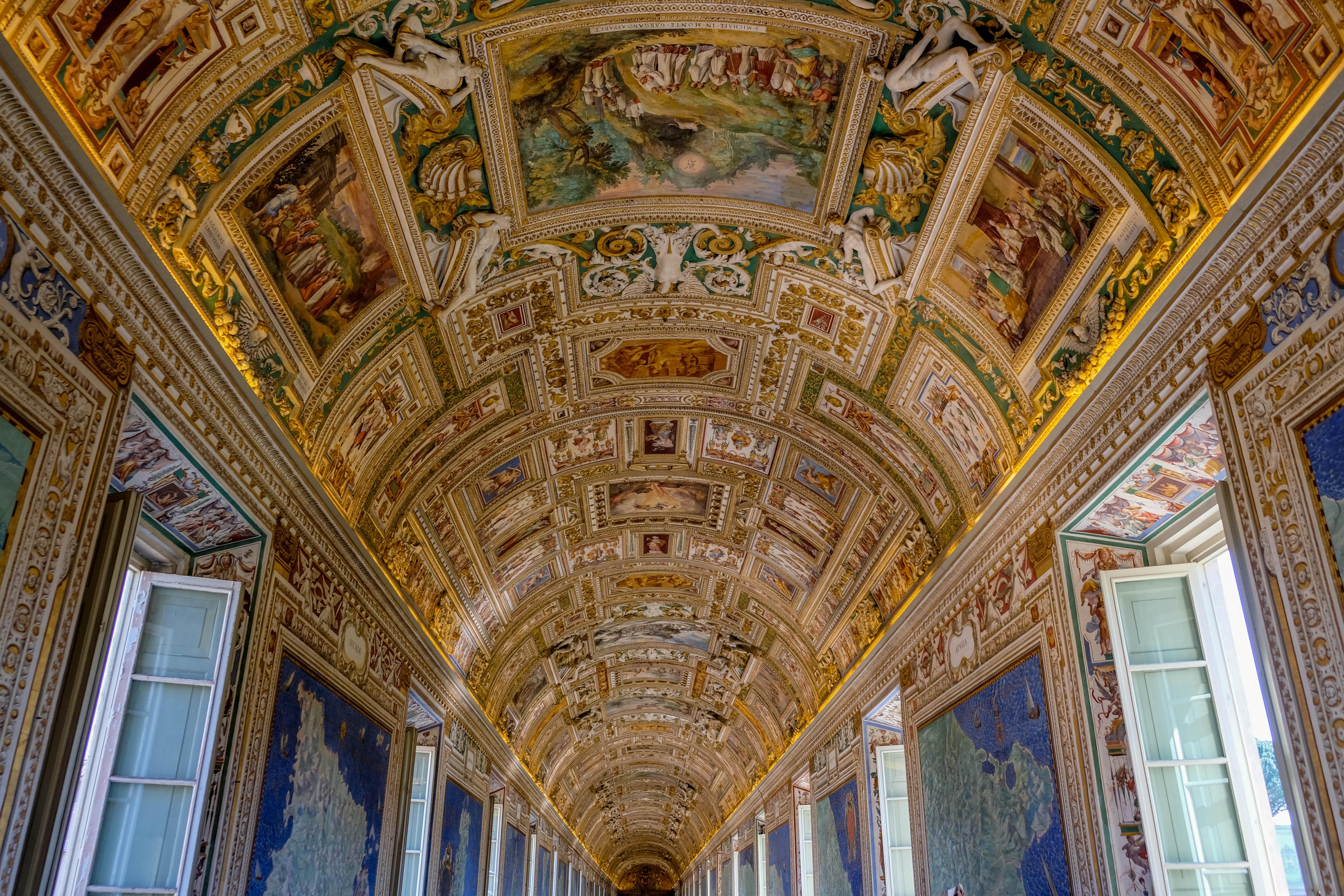
The Gallery of Maps is a spectacular hall inside the Vatican Museums that houses a series of large, stunningly detailed maps of Italy. The gallery was commissioned by Pope Gregory XIII in the late 16th century as part of a larger plan to renovate and modernize the Vatican.

The architectural genius behind the gallery's creation is Ignazio Danti, an accomplished Italian architect renowned for his mastery of mathematics and cartography. Danti's vision birthed a space of elegance and purpose, defined by its rectangular layout adorned with a gracefully arched ceiling. To infuse the gallery with natural illumination and a sense of openness, Danti incorporated a series of generous windows that grace both flanks. This symphony of design elements harmonizes to create a sanctuary where historical treasures come to life and visitors are immersed in a captivating journey through time.
Must Read : Inside Vatican Museums

Nestled within the Vatican Museum is the awe-inspiring Gallery of Maps, adorned with an exquisite collection of 40 grand-scale maps. These masterpieces, brought to life between 1580 and 1585 through collaborative efforts of skilled artists and cartographers, command attention. Each map, spanning approximately 13 feet in height and 20 feet in width, boasts an impressive magnitude. These captivating depictions were skillfully applied to the gallery's walls utilizing the fresco technique, seamlessly melding art and architecture to create an immersive tableau of geographical and historical narratives.
Also Read: Vatican Library

The maps within the Gallery of Maps vividly portray the diverse landscapes of Italy, capturing its myriad regions, prominent cities, islands, and territories. Woven into these expansive depictions are not only geographical details but also intricate illustrations depicting pivotal historical occurrences and iconic figures that have left an indelible mark on each distinct area. The maps thus serve as dynamic windows into Italy's multifaceted history, seamlessly interweaving both the physical and cultural dimensions of the nation's rich heritage.
Suggested Read: Lapidary Gallery

Beyond their artistic allure, the maps housed within the gallery hold profound significance as exemplary specimens of late 16th-century cartography. These cartographic marvels skillfully employ a spectrum of techniques, such as perspective, shading, and relief, to ingeniously craft a semblance of three-dimensional expanse. Thus, these maps transcend mere aesthetic appeal, serving as intricate windows into an era's innovative approach to mapping and spatial representation.
Must Read: Room of the Chiaroscuri

As time passed, the Gallery of Maps endured the effects of humidity, pollution, and various environmental elements that took a toll on the frescoes. By the 1980s, recognizing the urgency of the situation, a significant restoration endeavor was embarked upon. This ambitious project aimed to meticulously mend and safeguard the maps, which had faced considerable challenges, including the pervasive issues of flaking and fading.
Also Read: Raphael Rooms

Beyond its aesthetic allure, the Gallery of Maps stands as a pivotal historical document, offering a captivating window into the multifaceted tapestry of Italy during the late 16th century. This remarkable space transcends its visual charm, serving as a tangible testament to the intricate interplay of politics, culture, and art that defined the era. It is a living testimony, encapsulating the essence of a dynamic period in Italy's history, inviting visitors to embark on a vivid journey through time and immerse themselves in the intricate threads of a bygone epoch.
Suggested Read: Pio Clementino Museum


FAQs Of Gallery Of Maps
What is the Gallery of Maps in the Vatican Museums?
The Gallery of Maps is a section of the Vatican Museums that features a long corridor decorated with a series of stunning 16th-century maps of Italy's regions and cities. The maps are hand-painted on the walls and the ceiling, making the gallery a unique and visually impressive space.
Also Read: Facts About the Vatican Museums
Who painted the maps in the Gallery of Maps?
The maps in the Gallery of Maps were painted by a group of Renaissance artists, including Ignazio Danti, Cesare Nebbia, and Girolamo Muziano. They used a technique called "grotesque," which involves intricate decorations of plants, animals, and other designs to frame the maps.
Also Read: Dress Code of Vatican
What is the history behind the Gallery of Maps?
The Gallery of Maps was commissioned by Pope Gregory XIII in the late 16th century as part of a larger renovation of the Vatican Palace. The gallery was meant to showcase the geographical and cultural richness of Italy and its regions, while also serving as a space for papal processions.
Suggested Read: Vatican Museums at Night
How long is the Gallery of Maps?
The Gallery of Maps is approximately 120 meters long, making it one of the longest corridors in the Vatican Museums. The maps cover the entire length of the walls, from floor to ceiling.
Also Checkout: Rules at Vatican Museums
What are some notable features of the Gallery of Maps?
Aside from the impressive maps, the Gallery of Maps features ornate decorations on the ceiling, including frescoes of the life of Pope Gregory XIII and allegorical figures of the virtues. The floor is made of marble and features a series of intricate patterns.
Must Read: Carriage Pavilion
How long does it take to see the Gallery of Maps?
The time needed to see the Gallery of Maps can vary depending on the visitor's interest and pace. However, most visitors spend around 20-30 minutes in the gallery, taking in the beautiful maps and decorations.
Also Read: Sistine Chapel
Are there any guided tours available for the Gallery of Maps?
Yes, the Vatican Museums offers guided tours that include the Gallery of Maps, as well as other sections of the museum. Visitors can choose from a range of tours depending on their interests, and a knowledgeable guide can provide insight into the history and artistry of the Gallery of Maps.
Suggested Read: Vatican Grottoes
Is photography allowed in the Gallery of Maps?
Photography is permitted in the Gallery of Maps, but the use of flash is not allowed. Visitors are asked to be respectful of others and not to obstruct the view while taking pictures.
You May Also Like: Collections in Vatican Museums
How can visitors access the Gallery of Maps?
The Gallery of Maps is located within the Vatican Museums and can be accessed through the museum's entrance. Visitors can purchase tickets in advance or on-site, and are advised to arrive early to avoid long lines. The museum is open from Monday to Saturday, and closed on Sundays and some religious holidays.
Also Read: Paintings in Vatican Museums
Explore Vatican Museums
Visitor's Guide
Tours